mastodon.online is one of the many independent Mastodon servers you can use to participate in the fediverse.
A newer server operated by the Mastodon gGmbH non-profit

Server stats:

11K
active users

#pawx

294 posts33 participants45 posts today

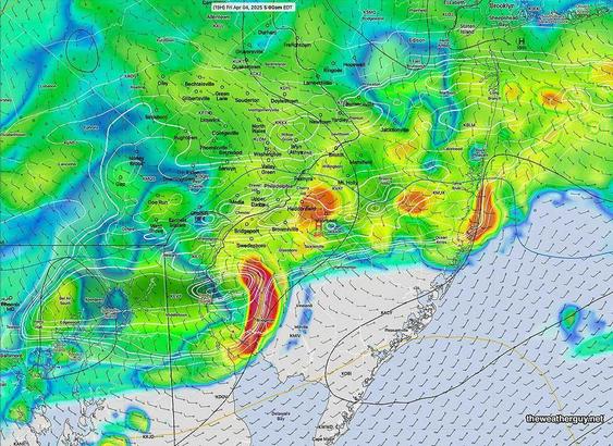
THIS WEEK’S WEATHER — #Philadelphia #weather #PAwx

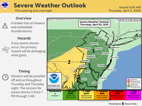
Strong Thunderstorms Possible Late Tonight

The warm front moved north of our area today, Thursday, allowing very mild and humid air to move into our region. The same air mass boundary will return tonight as a cold front.

The air over us is unstable and there is will be enough CAPE, vertical wind shear and helicity to aid in the formation of some strong, possibly severe thunderstorms in the 2 AM -6 AM time frame. theweatherguy.net

#CTP #PAwx 558
WUUS01 KWNS 032001
PTSDY1

DAY 1 CONVECTIVE OUTLOOK AREAL OUTLINE
NWS STORM PREDICTION CENTER NORMAN OK
0300 PM CDT THU APR 03 2025

VALID TIME 032000Z - 041200Z

PROBABILISTIC OUTLOOK POINTS DAY 1

... TORNADO ...

0.02 33768913 32149278 31409485 30739724 31319773 32599747
33799592 34379306 35259071 36578756 38058399 38728213
39787923 40207763 40527655 40387568 39787523 38977513
38467550 38097619 37587900 35978420 33768913
0.05 spc.noaa.gov/products/outlook/

#CTP #PAwx 746
WUUS03 KWNS 031924
PTSDY3

DAY 3 CONVECTIVE OUTLOOK AREAL OUTLINE
NWS STORM PREDICTION CENTER NORMAN OK
0223 PM CDT THU APR 03 2025

VALID TIME 051200Z - 061200Z

PROBABILISTIC OUTLOOK POINTS DAY 3

... ANY SEVERE ...

0.05 27059700 29049762 32249747 34129661 36919114 41088271
41617971 40857891 39847945 38258169 37088360 35608552
33878667 28848859
0.15 27989587 28379642 28899673 30949638 33009540 34609392
36189103 39458510 396883 spc.noaa.gov/products/outlook/

#CTP #PAwx 446
NWUS51 KCTP 031910
LSRCTP

Preliminary Local Storm Report
National Weather Service State College PA
310 PM EDT Thu Apr 3 2025

..TIME... ...EVENT... ...CITY LOCATION... ...LAT.LON...
..DATE... ....MAG.... ..COUNTY LOCATION..ST.. ...SOURCE....
..REMARKS..

0248 PM Tornado 7 W Keating 41.26N 78.05W
03/16/2025 Clinton PA Emergency Mngr

EF1 tornado confirmed mesonet.agron.iastate.edu/lsr/

mesonet.agron.iastate.eduIEM :: Local Storm Report AppIowa Environmental Mesonet of Iowa State University

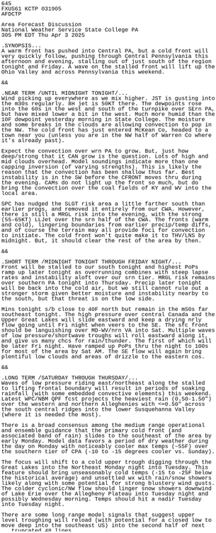
#CTP #PAwx 645
FXUS61 KCTP 031905
AFDCTP

Area Forecast Discussion
National Weather Service State College PA
305 PM EDT Thu Apr 3 2025

.SYNOPSIS...
A warm front has pushed into Central PA, but a cold front will
very quickly follow, pushing through Central Pennsylvania this
afternoon and evening, stalling out of just south of the region
tonight and Friday. A wave on the stalled front will lift up the
Ohio Valley and across Pennsylvania this weekend.

&&

.NEAR TERM mesonet.agron.iastate.edu/p.ph

mesonet.agron.iastate.eduIEM :: AFD from NWS CTPAFD issued by NWS CTP at 03 Apr 2025 19:05 UTC

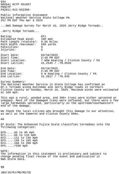
#CTP #PAwx 034
NOUS41 KCTP 031857
PNSCTP
PAZ011-012-032300-

Public Information Statement
National Weather Service State College PA
257 PM EDT Thu Apr 3 2025

...NWS Damage Survey for March 16, 2025 Jerry Ridge Tornado..

.Jerry Ridge Tornado...

Rating: EF1
Estimated Peak Wind: 100 mph
Path Length /statute/: 0.66 miles
Path Width /maximum/: 500 yards
Fatalities: 0
Injuries: 0

Start Date: 03/16/2025
Start Tim mesonet.agron.iastate.edu/p.ph

mesonet.agron.iastate.eduIEM :: PNS from NWS CTPPNS issued by NWS CTP at 03 Apr 2025 18:57 UTC

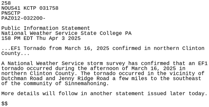
#CTP #PAwx 258
NOUS41 KCTP 031758
PNSCTP
PAZ012-032200-

Public Information Statement
National Weather Service State College PA
158 PM EDT Thu Apr 3 2025

...EF1 Tornado from March 16, 2025 confirmed in northern Clinton
County...

A National Weather Service storm survey has confirmed that an EF1
tornado occurred during the afternoon of March 16, 2025 in
northern Clinton County. The tornado occurred in the vicinity of
Dutchman Road and Jenny Ridge Road a few miles to mesonet.agron.iastate.edu/p.ph

mesonet.agron.iastate.eduIEM :: PNS from NWS CTPPNS issued by NWS CTP at 03 Apr 2025 17:58 UTC

#CTP #PAwx 579
FXUS61 KCTP 031702
AFDCTP

Area Forecast Discussion
National Weather Service State College PA
102 PM EDT Thu Apr 3 2025

.SYNOPSIS...
A warm front has pushed into Central PA, but a cold front will
very quickly follow, pushing through Central Pennsylvania this
afternoon and evening, stalling out of just south of the region
tonight and Friday. A wave on the stalled front will lift up the
Ohio Valley and across Pennsylvania this weekend.

&&

.NEAR TERM mesonet.agron.iastate.edu/p.ph

mesonet.agron.iastate.eduIEM :: AFD from NWS CTPAFD issued by NWS CTP at 03 Apr 2025 17:02 UTC

#CTP #PAwx 067
FXUS61 KCTP 031641
AFDCTP

Area Forecast Discussion
National Weather Service State College PA
1241 PM EDT Thu Apr 3 2025

.SYNOPSIS...
A cold front will push through Central Pennsylvania today before
stalling out of just south of the region tonight and Friday. A
wave on the stalled front will lift up the Ohio Valley and
across Pennsylvania this weekend.

&&

.NEAR TERM /UNTIL 6 PM THIS EVENING/...
Dying squall line has just crossed the Allegheny crest mesonet.agron.iastate.edu/p.ph

mesonet.agron.iastate.eduIEM :: AFD from NWS CTPAFD issued by NWS CTP at 03 Apr 2025 16:41 UTC

#CTP #PAwx 534
FLUS41 KCTP 031633
HWOCTP

Hazardous Weather Outlook
National Weather Service State College PA
1233 PM EDT Thu Apr 3 2025

PAZ019-024>028-033>036-049>053-056>059-063>066-041645-
Southern Centre-Cambria-Blair-Huntingdon-Mifflin-Juniata-Somerset-
Bedford-Fulton-Franklin-Union-Snyder-Montour-Northumberland-Columbia-
Perry-Dauphin-Schuylkill-Lebanon-Cumberland-Adams-York-Lancaster-
1233 PM EDT Thu Apr 3 2025

This Hazardous Weather Outlook is for central Pen mesonet.agron.iastate.edu/p.ph

mesonet.agron.iastate.eduIEM :: HWO from NWS CTPHWO issued by NWS CTP at 03 Apr 2025 16:33 UTC

#CTP #PAwx 132
WUUS01 KWNS 031631
PTSDY1

DAY 1 CONVECTIVE OUTLOOK AREAL OUTLINE
NWS STORM PREDICTION CENTER NORMAN OK
1130 AM CDT THU APR 03 2025

VALID TIME 031630Z - 041200Z

PROBABILISTIC OUTLOOK POINTS DAY 1

... TORNADO ...

0.02 33378962 32459160 31409485 30739724 31319773 32599747
33799592 35009419 35829172 36968811 38028486 38728213
39787923 40207763 40527655 40387568 39787523 38977513
38467550 38097619 37477924 36198348 33378962
0.05 spc.noaa.gov/products/outlook/

#CTP #PAwx 515
NOUS41 KCTP 031238
PNSCTP
PAZ046-032000-

Public Information Statement
National Weather Service State College PA
838 AM EDT Thu Apr 3 2025

...NOAA WEATHER RADIO ALL HAZARDS STATION PLANNED OUTAGE IN
WILLIAMSPORT...

NOAA Weather Radio All Hazards Station WXL-55, located in
Williamsport, may be off the air intermittently late this
morning and early afternoon due to maintenance at the site.

We apologize for the inconvenience.

$$
mesonet.agron.iastate.edu/p.ph

mesonet.agron.iastate.eduIEM :: PNS from NWS CTPPNS issued by NWS CTP at 03 Apr 2025 12:38 UTC

#CTP #PAwx 731
WUUS01 KWNS 031234
PTSDY1

DAY 1 CONVECTIVE OUTLOOK AREAL OUTLINE
NWS STORM PREDICTION CENTER NORMAN OK
0732 AM CDT THU APR 03 2025

VALID TIME 031300Z - 041200Z

PROBABILISTIC OUTLOOK POINTS DAY 1

... TORNADO ...

0.02 33378962 32459160 31409485 30739724 31319773 32599747
33799592 35009419 35829172 36968811 38028486 38728213
39787923 40207763 40527655 40387568 39787523 38977513
38467550 38097619 37477924 36198348 33378962
0.05 spc.noaa.gov/products/outlook/

#CTP #PAwx 499
FXUS61 KCTP 031136
AFDCTP

Area Forecast Discussion
National Weather Service State College PA
736 AM EDT Thu Apr 3 2025

.SYNOPSIS...
A cold front will push through Central Pennsylvania today before
stalling out of just south of the region tonight and Friday. A
wave on the stalled front will lift up the Ohio Valley and
across Pennsylvania this weekend.

&&

.NEAR TERM /UNTIL 6 PM THIS EVENING/...
Dying squall line has just crossed the Allegheny crest mesonet.agron.iastate.edu/p.ph

mesonet.agron.iastate.eduIEM :: AFD from NWS CTPAFD issued by NWS CTP at 03 Apr 2025 11:36 UTC

#CTP #PAwx 377
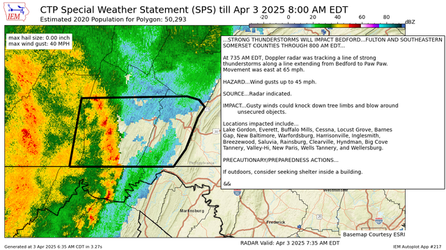
WWUS81 KCTP 031135
SPSCTP

Special Weather Statement
National Weather Service State College PA
735 AM EDT Thu Apr 3 2025

PAZ033>035-031200-
Bedford PA-Fulton PA-Somerset PA-
735 AM EDT Thu Apr 3 2025

...STRONG THUNDERSTORMS WILL IMPACT BEDFORD...FULTON AND SOUTHEASTERN
SOMERSET COUNTIES THROUGH 800 AM EDT...

At 735 AM EDT, Doppler radar was tracking a line of strong
thunderstorms along a line extending from Bedford to Paw Paw.
Movement was east at mesonet.agron.iastate.edu/p.ph

mesonet.agron.iastate.eduIEM :: SPS from NWS CTPSPS issued by NWS CTP at 03 Apr 2025 11:35 UTC
Replied in thread

#KYwx #OHwx #PAwx #WVwx

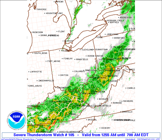
URGENT - IMMEDIATE BROADCAST REQUESTED
Severe Thunderstorm Watch Number 105
NWS Storm Prediction Center Norman OK
1255 AM EDT Thu Apr 3 2025

The NWS Storm Prediction Center has issued a

* Severe Thunderstorm Watch for portions of
Northeast Kentucky
Eastern Ohio
Extreme Western Pennsylvania
Western and Northern West Virginia
Lake Erie

* Effective this Thursday morning from 1255 AM until 700 AM EDT.

* Primary threats include...
Scattered damaging wind gusts to 70 mph possible
A tornado or two possible

SUMMARY...A fast-moving line of thunderstorms over western Ohio will
track eastward across the watch area overnight, posing a risk of
locally damaging wind gusts and perhaps a tornado.

The severe thunderstorm watch area is approximately along and 50
statute miles east and west of a line from 15 miles west of Erie PA
to 35 miles southwest of Huntington WV. For a complete depiction of
the watch see the associated watch outline update (WOUS64 KWNS
WOU5).

#CTP #PAwx 402
WWUS81 KCTP 031056
SPSCTP

Special Weather Statement
National Weather Service State College PA
656 AM EDT Thu Apr 3 2025

PAZ033-031130-
Somerset PA-
656 AM EDT Thu Apr 3 2025

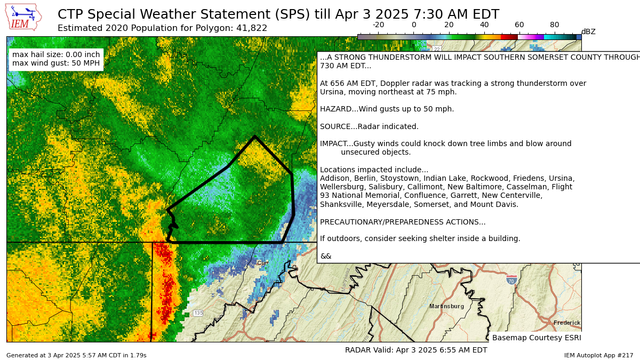
...A STRONG THUNDERSTORM WILL IMPACT SOUTHERN SOMERSET COUNTY THROUGH
730 AM EDT...

At 656 AM EDT, Doppler radar was tracking a strong thunderstorm over
Ursina, moving northeast at 75 mph.

HAZARD...Wind gusts up to 50 mph.

SOURCE...Radar indicated.

IMPACT...Gusty winds could mesonet.agron.iastate.edu/p.ph

mesonet.agron.iastate.eduIEM :: SPS from NWS CTPSPS issued by NWS CTP at 03 Apr 2025 10:56 UTC

#PAwx

Area Forecast Discussion
NWS State College PA
602 AM EDT Thu Apr 3 2025

NEAR TERM

Dying squall line has just crossed the Allegheny crest and the line has weakened as it approaches Altoona. Local gusts GT 45 mph still possible through 6:30 AM, but with more stable stratification and dewpoints in the 40s east of the mountains, the threat for strong gusts is decreasing early today, and we are not anticipating widespread impacts along and east of the Laurels given observed tendancy and line moving into more stable air with lower dewpoints in the 40s east of the mountains. Farther east, stability remains high while llvl moisture from persistent southeast flow results in plenty of low clouds and fog blanketing the ridges this morning. Temps steady or slowly rise through dawn, rising into the 50s almost everywhere and near 60F in the Laurels at sunrise.

The baroclinic zone sags ESE across western and central PA this morning with highest POPs now through 15z across northern and central areas, and lingering through 18z for the Laurel Highlands as the front stalls south of the Mason Dixon line later on. Main question for today is whether recovery is allowed to occur in a sheared and mostly cloudy environment. Far southeast may stand the greatest chance for storms as the boundary remains nearby and binovc may provide enough sfc heating to initiate. Most CAMs downplay this potential however, and we are leaning in this direction as well at this time.

#CTP #PAwx 758
FXUS61 KCTP 031002
AFDCTP

Area Forecast Discussion
National Weather Service State College PA
602 AM EDT Thu Apr 3 2025

.SYNOPSIS...
A cold front will push through Central Pennsylvania today before
stalling out of just south of the region tonight and Friday. A
wave on the stalled front will lift up the Ohio Valley and
across Pennsylvania this weekend.

&&

.NEAR TERM /UNTIL 6 PM THIS EVENING/...
Dying squall line has just crossed the Allegheny crest mesonet.agron.iastate.edu/p.ph

mesonet.agron.iastate.eduIEM :: AFD from NWS CTPAFD issued by NWS CTP at 03 Apr 2025 10:02 UTC